Blizzard Potential for Eastern Dakotas and Western Minnesota
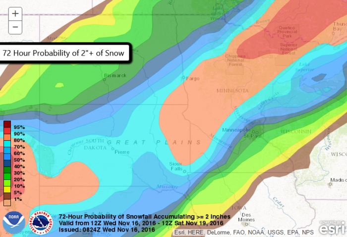
Winter weather watches have been posted as the first winter storm of the season sets its sights on the Northern Plains. Heavy snow and strong winds are expected in far eastern South Dakota, southeastern North Dakota, and western Minnesota starting late Thursday night and lasting through Friday night. A Blizzard Watch has been issued for these locations.
A blizzard is set to hit western MN Friday with heavy snow, strong winds, and whiteout conditions. NOW is the time to prepare. #mnwx #wiwx pic.twitter.com/ZFJIG8jbmX
— NWS Twin Cities (@NWSTwinCities) November 16, 2016
From the National Weather Service in the Twin Cities:
SNOW ACCUMULATIONS OF 6 TO 10 INCHES ARE EXPECTED WEST OF A LINE FROM AROUND GRANITE FALLS TO
WILLMAR AND LITTLE FALLS...GUSTS OF 35 TO 50 MPH ARE EXPECTED...HIGHEST SOUTH OF I-94 WHICH
WILL CONTRIBUTE TO CONSIDERABLE BLOWING SNOW AND WHITEOUT CONDITIONS. TRAVEL WILL BECOME VERY
DIFFICULT OR IMPOSSIBLE IN AREAS OF THE HEAVIEST SNOW.
This is the first real taste of winter for many in the Northern Plains so it’s very important to remember to prepare your vehicle for winter driving. Also, after this system departs the region, the coldest air of the season will plunge in from Canada. Lots of big changes are coming! Pay attention to local forecasts as things could still change.


What People Are Saying...
Twitter Mentions
Reddit
Jetpack Comments
Comments are closed here.